


 Maps
Maps
Matches 1 to 16 of 16 » Thumbnails Only » Slide Show
| # | Thumb | Description | Linked to |
|---|---|---|---|
| 1 | 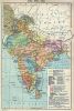 | India, 1700-1792 Historical Map of India, during 1700-1792 | |
| 2 | 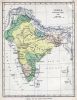 | India, 1760 Historical Map of India, during the period of Robert Clive, 1760 | |
| 3 | 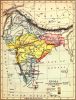 | India, 1785 Historical Map of India, during 1785, at the close of the Government of Warren Hastings | |
| 4 |  | India, 1804 Historical Map of India, during 1804 | |
| 5 | 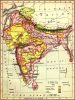 | India, 1875 Historical Map of India, during 1875 | |
| 6 | 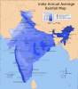 | India, Annual Average Rainfall Map Annual Average Rainfall Map of India | |
| 7 | 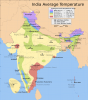 | India, Annual Average Temperature Map Annual Average Temperature Map of India | |
| 8 | 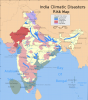 | India, Climatic Disaster Map Climatic Disaster Map of India | |
| 9 | 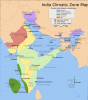 | India, Climatic Zone Map Climatic Zone Map of India | |
| 10 | 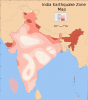 | India, Earthquake Zone Map Earthquake Zone Map of India | |
| 11 | 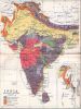 | India, Geological Map, 1983 Geological Map of India, 1983 | |
| 12 |  | India, Languages, 1983 Linguistic Map of India, 1983 | |
| 13 | 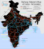 | India, Railways Railways of India, Schematic | |
| 14 | 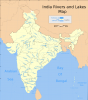 | India, Rivers and Lakes Rivers and Lakes of India | |
| 15 | 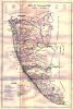 | Kerala - Travancore, 1940 Historical Map of the State of Travancore, during c.1940 | |
| 16 | 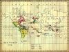 | World, 1772 Historical World Map, during 1772 |